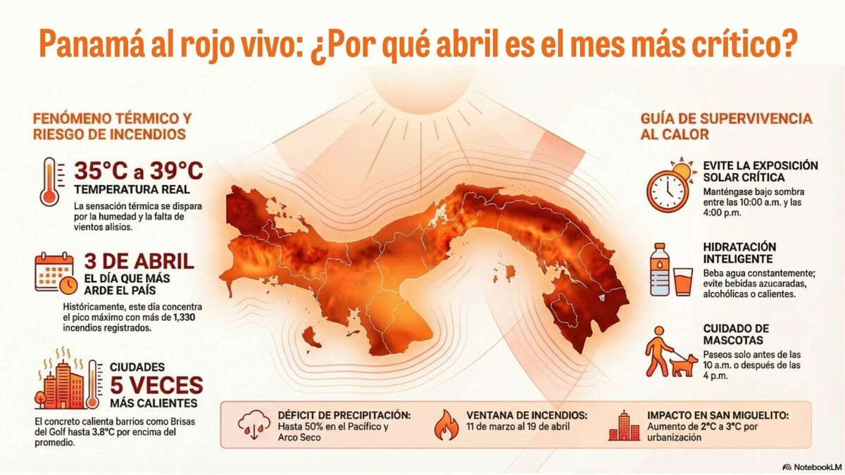
April brings with it high temperatures. With the arrival of spring in the northern hemisphere, the sun's rays impact Panama more directly, causing temperatures to soar, exceeding 35 °C in several regions, while humidity makes the heat feel even more intense. This is compounded by the decrease in trade winds, raising temperatures between 34°C and 39°C. The Institute of Meteorology and Hydrology of Panama (Impha) maintains alerts for high heat index in several provinces, while satellite information from Esri Panama, in conjunction with the Florida State University Urban Risk Observatory, indicates that April 3rd is the day of the highest risk of forest fires this year, precisely when the heat combines with the dryness of the fields. The high-temperature watch, effective until 6:00 p.m. on April 5, 2026, covers the lowlands of Chiriquí, Veraguas (south and center), Los Santos, Herrera, Coclé, Panamá Oeste, Panamá, Darién, the Emberá Comarca, Colón, and the coasts of Guna Yala, Ngäbe Buglé, and Bocas del Toro. According to meteorologist Emanuel Velásquez, temperatures could exceed 35 °C, with an even greater heat index due to humidity, making April a potentially record-breaking month for heat. April 3rd: The day Panama burns the most. The thermal increase coincides with the critical forest fire season, which historically peaks around April 3, according to a 25-year geospatial analysis by Esri Panama in collaboration with the Florida State University Urban Risk Observatory. Panama is facing its most dangerous annual window for forest fires, concentrated between March 11 and April 19, with a historical peak detected on April 3, according to the study. On average, more than 1,300 fires are recorded on that day, a recurring and predictable pattern that demands preventive action. The analysis identifies critical zones in dry ecosystems and areas with high agricultural activity, where the accumulation of biomass and uncontrolled burns increase the risk. The province of Veraguas leads the national statistics with 9,939 forest fires, representing 20% of all events in the country. 'The value of this analysis is that it transforms a perception into certainty. It's not your house or your street... it's all of Panama that is almost getting scorched. The scientific explanation is that the sun's rays fall almost perpendicularly on Panama, generating very high radiation and little cloudiness. The geographical position has always been a great advantage for Panama: our main asset, the center of the world, the heart of commerce. When you identify patterns in time and space, you can anticipate scenarios and act with precision,' explained Rocío Vega, General Manager at Esri Panama. Vega also specifies that the heat and low humidity make fire spread faster, which turns April into a month of double alert: for heat and for fires. The study is supported by the use of integrated and analyzed satellite imagery, which allows for visualizing historical trends, detecting patterns, and generating interactive tools for decision-making. Visualize the behavior of fires in the interactive application. This extreme heat not only affects the countryside and increases the risk of fires, but the city is also paying the price. The same Esri Panama led a study that confirms that the way we build is heating our environment five times faster than the global climate crisis. For this reason, sectors like Brisas del Golf and Juan Díaz have seen surface temperatures rise by up to 3.8 °C, while San Miguelito, Betania, Pueblo Nuevo, Río Abajo, Casco Antiguo, and Bella Vista show increases of between 2 and 3 °C. An increasingly hot city reminds us that April's heat is not just a number: it is a phenomenon that directly impacts our daily lives. No one is spared from the intense heat.